Category Archives: Devon

South West Coast Path – Churston Cove – Paignton Walk – 26.05.2012

“Torbay is a place which endears itself to the patriot, the naturalist and the artist.”
Charles Kingsley, author of The Water Babies

Indeed I can see why. Whilst lazing on the beach, the sun beaming down on me and the sea gently coming into the shore, nothing seemed to be wrong the the World. Whilst I was starting across the bay, there was something lurking under the sea water… an underwater lawn! The lawn is actually Seagrass (Zostera Marina) which grows beneath the waves harbouring lots of sealife. The unknown grassland, inspired the author Charles Kingsley, who was the well known author of the Water Babies, to write about the lawn in his book the “Wonders of the Shore”.

We could not sit for too much longer as we both seemed to get itchy feet! We both wanted to continue our journey :-). The path wound it’s way around the cliff edge, giving us quite a beautiful view of the cove, we could even see further out to Brixham breakwater! The path departed the coastline here and we started to walk through “Elberry and Marridge Woods”. These did not seem to be as dark and foreboding as the wood that I had previously encountered. This was probably as the trees were not as dense and path much wider and easier to walk along!

From 26.05.2012 – South West Coast Path – Churston Cove – Paignton

These woods have been in the area for over 400 years. Trees such as the Larch and Sweet Chestnut grow here. At first I did read the information post incorrectly and thought we were walking the “Marriage Woods” and thought that was rather a romantic name for a woodland! I was quite disappointed when I was wrong.

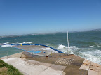
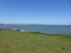
The path eventually took us out on to the lovely little “Elberry Cove”. We were struck by a odd stone building that was sat in the corner of the bay. The most usual explanation for these kind of structures are for fishing ? It seems that this was the Bath House of Lord Churston. It seems that this building was built so the Lord could swim directly in the sea when the tide was right and the building even had a hot bath! It seems that the Lord built such a Bath House after King George III took a dip in the sea in Weymouth!

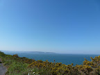
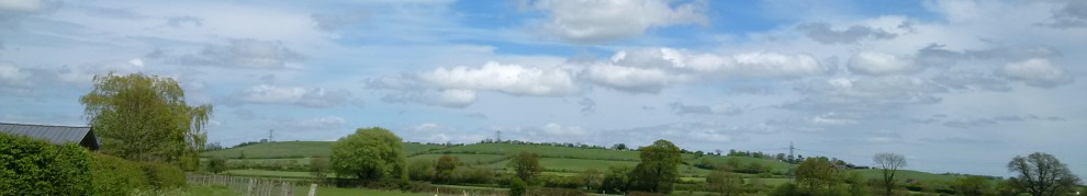
We left the Cove behind to continue our trek, onto towards Broadsands. We were once again on the ascent, and were back on a cliff edge. The path was crossing “Elberry Common”, which was once a Rabbit Warren! The common is quite a large expanse of land so a I can imagine the warren would have had a lot of rabbits!! As there no trees on the common there was a great view across all of Torbay.

From 26.05.2012 – South West Coast Path – Churston Cove – Paignton

From the Commom, the path descended into the lovely “Broadsands”. We walked along the beachfront for a while, before the path took us took away from the coast and uphill. As we started to climb a some steep steps, I was taken by surprise when a Steam Train start to come towards us on the nearby Viaduct! The South West Coast path was taking us right by the “Paignton and Dartmouth Steam Railway”.

There had been a line in this part of South Devon since the mid Nineteenth Century, and despite being threatened with closure in by the early 1970’s, a private enterprise ensured the line stayed alive. By 1973 the line was back up to Mainline standards and able to carry the largest and heaviest locomotives in Britain!

The path continued to follow alongside the Railway and took us along the rolling countryside. We eventually found ourselves in “Goodrington Sands”. It really did feel like a great day at the sea side! Beach Huts, gorgeous sand, sea gently coming in and Sun streaming down. Shame we did not stop, even for a drink at the pub, which has a interesting history! The pub, was originally an old Naval Hospital built for to care for the casualties of the Napoleonic War. We followed the path around Goodrington Bay and up on along a steep cliff. The hike is worth it just for the view alone 🙂

From 26.05.2012 – South West Coast Path – Churston Cove – Paignton

At the top of the cliffs were some really lovely maintained gardens. I then I realised we had reached Paignton! I did discover a very strange sight, some knitted Union Jacks which had been placed on all the lamp posts! These seemed to have been especially created for the Queens Jubilee? If anyone could give me any information about these great creations it would be appreciated!

Our journey continued on into Paignton, taking us past the harbour. The harbour was established during the early 19th Century under the “Harbour Act”. Prior to this Paignton was a small fishing village and was originally spelt “Peynton” which was derived from Celtic Settlement which was in this area, known as “Paega’s town”.

The path took us past the Paignton Green and towards Paignton Pier. This pier had been standing here since it had been built in 1879. Despite the Pier suffering some misfortune in it’s lifetime including a fire destroying some of its buildings and later being partitioned as a defence measure during the Second World War, the Pier is still alive and well today!

It is here we ended our walk for the day by walking to the end of Paignton Pier and staring out to sea. 🙂

For all the afternoon’s Walk photos please feel free to click here and browse through them!

26.05.2012 – South West Coast Path – Churston Cove – Paignton

<><

South West Coast Path – Berry Head – Churston Cove – 26.05.2012

The sun was shining, the views were indeed spectacular, therefore a walk to continue our journey on from Berry Head was definitely in order! We passed by both Napoleonic Forts, to reach the end of the path at the Cliff Edge where we did not complete the walk along the path yesterday. This time when I looked over to gaze at the sea views, the Sea was not as meek and mild as it had been previously, as the waves were crashing against the Breakwater with Gusto!

From 26.05.2012 – South West Coast Path – BerryHead – Churston Cove

We followed the Coast path towards Brixham. Unfortunately it did not really feel like a “Coast Path”, as the path descends through a woodland area. On a very warm day like we were experiencing, it did not really matter, particularly as the shade the trees gave a great protection from the rays of the sun. I will admit, that I have started to enjoy the diversity of this path, from these woodlands, to narrow paths on steep cliffs, to to Seafronts! and gentle cliff tops :-)!

The path finally came out at a road. In fact there are no many signs as to where to go, but I think we made a logical deduction to follow the road towards the sea front! We found ourselves looking at “Shoalstone Outdoor Pool”. Unlike some of the Lidos, that I had encountered in the past such as the Cliftonville Lido and the Barking Lido it seems that Shoalstone Pool had remained relatively intact! The Pool was built during 1896 and during 1926 the pool was slightly altered to increase it’s size. A local lady gave the pool a great tradition of diving into the pool at the start of each season wearing a Union Jack just after the pool reopened after the Second World War! Despite threats of closure during the recent years, the pool has survived and still going strong today. I must admit when I saw the words “Closed” painted on the side of the pool – I didn’t realise it meant for the season, but with the waves crashing over the edge of the Pool Wall I was not going for a dip!

From 26.05.2012 – South West Coast Path – BerryHead – Churston Cove

We walked on towards Brixham and to Breakwater Beach. The beach here may not be sandy and is quite small, but it is quite nice. We followed the path into Brixham Marina. The sea on this side of the Breakwater wall is so different. It is so calm, there were no waves at all! The noise we could hear was the wind whistling through Yacht Masts, it was certainly very eerie. The stroll along the Marina, was really pleasant, particularly as the Brixham residents had created beautiful little gardens along the Marina walls. These gardens were thanks to the “Pride in Brixham” volunteer group, their hard work had even won them some gardening awards. 🙂

We were now in the Harbour area, and we passed by the “British Seaman’s Boys Home” . The building was in fact Grenville House built in 1863 by William Gibbs, with it sole intention to provide a home for the sons of any British Seamen who had passed away. It remained open up until 1988, however, the house re-opened in 1990 as an outdoor and educational centre! I think it was well used, we definitely heard lots of noise emanating from there!

As we carried on our walk, we discovered that Brixham Marina did not just cater for the latest yachts, but had a small number of much older boats as well. In fact Brixham had the world’s largest fleets of wooden sailing trawlers. The 6 boats that are in the Harbour today are the only trawlers which remain in existence today. I was shocked to find a much older boat in the Marina, the Golden Hind! I thought I was having a touch of dejavu since I saw the same ship back in London in February? It seems that Francis Drake’s ship was obviously such a beautiful ship that it has been recreated twice!

From 26.05.2012 – South West Coast Path – BerryHead – Churston Cove


We stopped in the Lovely Brixham for a while. I treated myself to a great Ice Cream (Salcombe Diary) and explored the area for a while before we carried on our walk. It is a shame that I did not capture any more photos here, particularly of All Saints Church. It is here, that Reverend Henry Lyte wrote the Hymns ‘Oh Worship The King’ and ‘Praise My Soul the King of Heaven’ and 1847, months before he passed away, he wrote the Hymn

Abide with me; fast falls the eventide;
The darkness deepens; Lord with me abide.
When other helpers fail and comforts flee,
Help of the helpless, O abide with me.

We carried on our journey around the Harbourside, and past the fish market. The path was pointing us in the direction of the Battery Gardens. Whilst on route, I was curious about the signs for Blackbeards Trail! I have since downloaded the PDF of the trail and it is very informative! The path ascended into what is now known as Battery Gardens. During the Second World War, there had been a whole Battery of Guns located here so that it would defend the entire bay. However, the actual Battery location is much older than the 20th Century. In fact there has been battery sited here, protecting the bay, since the 16th Century when England was at war with Spain. It certainly had a great position over Torbay and in fact these particular defences are not so exposed as the Berry Head Forts!

We carried on along the path which became very narrow to walk along where we reached Fishcombe Cove. Despite a lovely little cafe being sited here, we still decided not stop here and continued on. The path continued to climb and came out into a road and no longer followed a coastal route. The path followed leafy lane where it eventually came to a crossroads. We had a choice to either go to the little village of Churston Ferrers or on to Churston Cove. We choose to go on to the Cove which was a steep descent through a woodland area. As we had not stopped Fishcombe Cove, we decided to sit and rest in Churston Cove for while and watch the waves roll onto the beach!

For all of the photos for this part of the walk –


26.05.2012 – South West Coast Path – BerryHead – Churston Cove

<

South West Coast Path – Berryhead Walk – 25.05.2012

It was a stunning afternoon, and I had another chance to explore yet another part of the South West Coast Path.  The sun was shimmering over the horizon, making a wonderful haze, I could have just looked over the cliff edge at the ever changing sea for the rest of the afternoon if I am entirely honest. But it did not take long for the walker in me to take over and start wandering along the track.

The path was to take us along to the “Berry Head”. It seemed like an easy enough route to me, straight ahead and uphill? Yet the “South West Coast Path” does not follow the Coastal route! The path actually took us around and into the Berry Head Visitors Car Park. It was not long, however, before the path rejoined the other “coast path” as I nicked-named it! The path then took us up to the Berry Head, where it stops short of the Cliff. I was brave enough to look across the cliff edge where I was rewarded with views across “Torbay”.

From 2012 – 25.05.2012 – South West Coast Path – Berryhead Walk

We left the path at this point, as the path continues to Brixham. We decided to follow that route the next day. Instead we headed towards the Napoleonic Fort, that is sighted on the Berry Head. This impressive Fort which was built on a limestone peninsula which is at least 65m (200ft high) . The fort was built during the Napoleonic Wars, 1794 – 1804, it’s main objective was to protect Brixham and Tor Bay from French attack.

As we passed through the very high and impressive gateway into the fort, there are sudden lack of buildings just a large expanse of grass. The outlying walls of the fort are still intact, giving us a good idea of exactly how large the Fort would have originally been. In fact it showed that the Fort would have been a similar size to the peninsula, as the walls seem to hug the Coastline. I would imagine that the fort could have been very daunting to any approaching ships in it’s hey day

From 2012 – 25.05.2012 – South West Coast Path – Berryhead Walk

As we started to explore the fort, I was nicely surprised to find a Beacon! This will have been the 8th Beacon I have located on my travels around the UK. If you like to read some of my other walks, Berwick Upon Tweed Walk, Purfleet, Wemyss Bay, Hainualt Country Park, Doniford Bay ,Canvey Island and Hastings all of these have had a beacon find! I am no longer going to name them “Millennium Beacons”, as they have since been lit for the Queen’s Diamond Jubilee. However, I have found out that approximately 4,500 beacons were lit on 4th June 2012 and if so I have only 3,492 to locate:-/

As we walked further out onto the Peninsula, it was became much easier to see how the Fort really dominated the bay. We began to really see how far out into the sea you are really able to see on a good day. In fact on a from one point, over 800 sq miles of Sea are visible! I doubt any approaching ships would have been able to hide from this Fort! We were not surprised, then, to find a Lighthouse built on the remains of this Fort, surely it can be seen for miles around. It was constructed in 1906 and the Lighthouse is the “smallest, highest and deepest” Lighthouse in the UK. As the Light was originally required to be turned by a weight in the 45m (~147.6ft) shaft below it, which has now been replaced by a small motor.

From 2012 – 25.05.2012 – South West Coast Path – Berryhead Walk

As we continued our walk around the Fort we discovered a well preserved Artillery Store for the Royal Regiment, which would have been used in approximately 1802. It seemed the Fort was not only used during the Napoleonic wars but during World War II as well. An Observation Post had been built here, which had been used by Royal Observer Volunteers to spot Enemy Aircraft. As we wandered our way out of the Fort, we walked past the Visitor Centre, which was surrounded by Canons, presumably these were originals from the site? I am not sure? Having seen them up close, and knowing that there would have have been a whole host of these guns pointing out to sea at one time in history, that would have been a very frightening sight

As we left the Northern Fort behind, it was time to walk to the “Southern Fort”. This time, we choose not to walk along the South West Coast Path. We walked along a path which was of the “Torbay Circular Walks”. The Path was a lot nicer to walk along, particularly as the route followed the Coastline. It was not long before we reached the Southern Fort, which unlike the Northern Fort, did not have a large Stone entrance. Perhaps that was long gone, the drawbridge had been reconstructed over the Moat which was still clearly visible (It was more like a ditch, as there was clearly no water in it!)

The Fort was built at the same time as the “Northern Fort” during the Napoleonic Wars, it seems that this Fort was a lot smaller that it’s counterpart, particularly as it contained only a single Barrack. The Fort is located on a a higher ridge and facing out in a slightly different part of the bay. The high walls and moat gave the Fort a great position the defend inland attacks as well as attacks from the sea.

As we explored inside the Fort, it was noticeable that this Fort had been adapted for use during the Second World War. An observation post had been put up so that someone to climb it and look out to sea to watch for those enemy ships. Lovely on days like we were visiting, but not on those cruel windy nights when the sea could be lashing against the cliffs!

From 2012 – 25.05.2012 – South West Coast Path – Berryhead Walk

We left the fort behind to continue along our chosen path, which eventually joined up with the South Coast Path once more. We finally reached a stop point when a cup of tea was in order before starting out on the path once more.

This part of the path was certainly less glamorous. It was narrower and took at one point I got confused when I saw the sign “Private Property”. Please keep to the path at the bottom of the field! I wasn’t sure I was at the bottom of any field? ! All very confusing, luckily I had just passed two walkers coming the other way so I knew I was ok! After walking through the field the path became very steep, I am glad that their had been no rain that day, because I had not been wearing walking boots and I would have definitely slipped on the mud if that was the case!

This stretch of the path was lined with trees, which hindered a lot of the lovely coastal views. Luckily at one point there was a small gap, where I could see the little Bay. This was St Mary’s Bay, which really beautiful to walk along. Unfortunately, I did not have any more time to continue my walk that evening to venture any further on along this route 😦 If I had more time to walk I would have been able to reach Sharkham Point. Despite me ending my walk here, I was not too sad I was going to do more walking the next day!

For all the afternoon/evening walk photos, please feel free to browse them, by clicking on the photo here –

2012 – 25.05.2012 – South West Coast Path – Berryhead Walk

<><

South West Coast Path – Hele Bay to Ilfracombe Walk

The path starts with a steep climb up the cliff side from Hele Bay.  I think I should have suspected how the how the steep the cliff walk was going to be considering I could see the gardens just down the road had shed’s half way up a hill!  Someone had what seem liked the Stairway to Heaven rather than steps to their house!

I digress, the path wound through a woody area – also known as Hillsborough – despite the trees you could still see a good view through the foliage.  Bizarrely the sun was out and it was hot it started to rain!  Which is not good under trees – instead of sheltering they always seem to make it worse.

From 2009 – 13.07.2009 – South West Coast Path – Hele Bay to Ilfracombe Walk

Luckily the rain dispersed quickly.  The path got a little confusing at one point, mainly as it crosses with many public footpaths through this wood and the path has had a new diversion put in place – the new route made you climb even higher!

The path then bends around what seems to be a like a dead end, and just a view point.  A wonderful view of Ilfracombe – well worth the hike from Hele Bay.

From 2009 – 13.07.2009 – South West Coast Path – Hele Bay to Ilfracombe Walk

Past the view point, you have to go through a few more woods, and into open land. Such a change of scenery. The path again is bit tough to work out the route – particularly as the little acorn signs weren’t that helpful! A little guesswork was needed. On the way through Hillsborough I encountered a Helicopter display – sadly it was not a good one. Air Sea Rescue was attending a woman who had hurt herself – don’t worry she had the best care there!

From 2009 – 13.07.2009 – South West Coast Path – Hele Bay to Ilfracombe Walk

Then the walk winds around to Ilfracombe, past the Swimming Pool and through the harbour. Personally I think I lost the path and made this part of the route up – but never mind – got to Ilfracombe with no problems! Particularly to recover with a short trip to the Chocolate Museum and the lovely Chocolate buttons – yum

From 2009 – 13.07.2009 – South West Coast Path – Hele Bay to Ilfracombe Walk

All the photos from the walk –

2009 – 13.07.2009 – South West Coast Path – Hele Bay to Ilfracombe Walk

<><

South West Coast Path – Hele Bay – Watermouth Evening Walk – 12.07.2009

The summer evenings of July still seem to last despite it being past the longest day, so to make most of the beautiful day which had being walking around Ilfracombe it was the perfect opportunity to tackle part of the South West Coast Path.

Unfortunately for part of the path from Hele Bay you have to walk down a coastal road, not too bad because you are easily be distracted by the views. The path takes a very strange route through a small car park, not much of the path if you ask me, just takes you to a view point, but I rapidly discovered that the viewpoint was worth the diversion from the road –

From 2009 – 12.07.2009 – South West Coast Path – Hele Bay – Watermouth – Night Walk Devon

Coming out of the car park to the road (again!) you turn off at the Coastguards house on to the proper coast path. Despite not having any walking boots on, the path was not too bad to tackle – not much mud despite any rain that we had. However, the path is not too well maintained on this route and you definitely feel like Indiana Jones most of the time –

The path winds itself up and down the cliffs, it passes by farmers fields and you end up hiking around the cliffs via a very long route. It was quite amazing to see the sheep and goats being able to graze on such a steep incline if you ask me – must have some sort of in built balance system…

From 2009 – 12.07.2009 – South West Coast Path – Hele Bay – Watermouth – Night Walk Devon

The cliffs seem to be much higher than the Cornwall cliffs that I encountered, and in fact they seemed more challenging – (except the Cornish ones came complete with disused tin mines and danger of death everywhere – I think I covered that in a previous blog) The hike is well worth the struggle, the views are spectacular and amazingly enough the path actually has benches dotted along it. But I didn’t really get time to sit down and contemplate the views, I understand these cliffs are some of the highest in Britian.

From 2009 – 12.07.2009 – South West Coast Path – Hele Bay – Watermouth – Night Walk Devon

I carried on round to see Watermouth bay in the distance – The bay lit up with yacht lights like some sort of Christmas tree.

The path moves away from the coastline because of farmers land, I think by this point I realised the early evening stroll was turning out to be a little bit longer than that, as it was getting very dark – in fact you have to cross a stile, in to what seems like a black hole

From 2009 – 12.07.2009 – South West Coast Path – Hele Bay – Watermouth – Night Walk Devon

The trees completely cover the path and you seem to walking through a tunnel, your in a dark, wild and lonely place, and just as I was walking down the path, two bats shot out of the wall right in front of me! Felt like a personal attack. I ended up walking through a wood which was strange for a coast path if you ask me.  The path also follows the roadway at one point which is only separated by a wall. It was then time to come off the path, as I had reached Watermouth Castle – a bit later than planned and well the whole walk was much longer than planned…

It was then time to hike the short way back via the road back to the tent and a well deserved cup of tea

All the photos from the evening walks are –

2009 – 12.07.2009 – South West Coast Path – Hele Bay – Watermouth – Night Walk Devon

<><

Ilfracombe (Including Capstone Point) – 12.07.2009

Ilfracombe is a small coastal town, rather than a village, so the south west coast path cuts right through town to capstone point. As it was a leisurely day, it seemed appropriate to walk around the town, which included a small hike up the hill past the harbour to Nicholas Chapel – it is still used – but mainly by the rotary club these days. The chapel had also been used as a lighthouse and a home – but still remains a chapel The view wasn’t bad of the harbour, but the other way was just a clear to Capstone….

The harbour itself is a haven for fishermen – their were loads of fishermen on the pier, I was even warned to duck as the cast their line. It was a pier with no amusements or roller coasters, just a pier for docking boats and fishing. Quite a nice change really.

After a short diversion to buy an ice cream, (excuse was the hill that I just walked up and then back down from the chapel!) the walk took me through town and then to Capstone. The coastal path just goes around the cliff but instead of going around the hill I decided to climb it. Although I did hesitate with the falling warning of fall rocks (not very stable then…) The hill was much steeper than the chapel and proved a little tough on the legs – well this is the first real hike for at least 2 weeks!

At the top, there is a flagpole, but there is absolutely no information as to why it was there or anything. Suppose it just looked good. As it was so windy the flag was making a racket – it seemed much noisier than listening to rain hitting my tent! You have a clear view of the jubilee gardens, the bandstand, the landmark theatre (which looks very strangely and looks more like water cooling towers than a theatre if you ask me) Unfortunately you couldn’t see the tunnel beaches (which I sadly missed this trip – oh well I suppose that means another trip 🙂 ) You could also see the little museum – which I since learned used to be a laundry for the Ilfracombe Hotel in C19th.

I think going down seemed just a tough going up, may be I should have taken a leaf out of other peoples book and rolled down the hill, looked far more fun than just walking it. When you reach the bottom of the hill you come to the coast path – the rocks are quite dangerous and I can imagine in winter this part of the path being shut – particularly if the waves batter them quite hard. (the falling rocks warning made sense now!)

Coming back round it was time to sit and rest by the bandstand, unfortunately I had picked a day when there was no band to listen to – oh well.

2009 – 12.07.2009 – South West Coast Path – Ilfracombe

<><