Monthly Archives: June 2011

Berwick Upon Tweed Walk – 21.05.2011

This was to be our last walk in Berwick. After our long walk around the town on the previous day or so, what else where we to find?  We decided to change our route out of the caravan park, taking the coast path instead of the usual town road via the station. We passed by Berwick Upon Tweed Castle Watchtower, which had once been part of the Berwick Upon Tweeds Castle. This impressive tower had a prominent position, which gave it a lovely view across the bay.

From 2011 – 20.05.2011 – Berwick Upon Tweed Walk

The path turned off the coastal route into road. We were surprised to be faced with a fishing boat in the middle of a road! In fact we were in Low Greens – in the heart of an old fishing community.   The community was actually known as the Greenses Arabs – as they were a community of Flemish, Portuguese,  French, Spanish and locals.  The  harbour had been in existence since the 1700’s right up until the mid 20th Century.  The main catch was Salmon.   Sadly the harbour no longer exists – but the area is very much a close local knit community.

As we turned away from low greens, it was not long before we found ourselves at castlegate. Obviously this was the shortcut we had been missing all the time we had been staying there! As we made our way the the archway, I noted that the supermarket car park was at one time a cattle market which had been established way back in 1886.

We made our way through our way along the high street and passed the town hall and the old berwick stocks (and no I wasn’t put in them!). It was not long before we were walking the back streets of Berwick and we found not one but two references to Lowry that we did not find previously. The first was “Sally Port” and the second was “Dewars Lane” which L.S Lowry had captured in pencil. As we turned around the corner to take one last look at the River tweed, we came across “Sally Port” which was another one of Lowry’s creations. It seems he had been everywhere in Berwick!

From 2011 – 20.05.2011 – Berwick Upon Tweed Walk

We just had time to stop in a local cafe to try a local ice cream – Doddingtons diary to be precise! Yum Yum! Before finishing our walk and in fact our break in Northumberland!

For all the photos for the shortest walk of the break –

2011 – 20.05.2011 – Berwick Upon Tweed Walk

<

Edinburgh Walk – 19.05.2011

“Athens of the North” – This is where we were headed today. Using the high speed train and travelling approximately 60 miles (~ 96 km) we found ourselves walking the Capital city of Scotland – Edinburgh.

It was in stark contrast to Berwick Upon Tweed. Instead of a relaxed town atmosphere, we could feel immediately that you were in the midst of a busy city. Nevertheless, the city maintained an historic feel – despite the brand new shopping mall by Waverley Rail Station. Since we had no real route plan we decided to take Edinburgh in our stride – particularly as we only had the afternoon to look around the city.

We wandered slowly down the “Princes Street” – one side being busy shops – whilst the other is flanked by “Princes Street Gardens”. Whilst walking along a huge Gothic structure caught my eye. In fact this is monument which is known as “The Scott Monument”; built to commemorate the works of the Poet Sir Walter Scott. What a wonderful tribute to have built in his memory.

From 2011 – 19.05.2011 – Edinburgh Walk

It was not long before we passed by the Royal Scottish Academy. I wonder if Lowry had displayed any art there… which I very much doubt??? This Academy building has been in existence since 1826. It was designed by William Henry Playfair – an eminent Scottish Architect – he had been responsible for many other buildings around Edinburgh such as the Old College, St Stephen’s Church and the City Observatory. As we continued along, Edinburgh Castle had always remained in the skyline – it dominates Edinburgh City – it seemed like a good idea to visit it!

We decided to at least take in some more sights of Edinburgh before trying to find a route to the castle. We turned off Princes Street – to see where we would end up! We discovered a huge round building – reminiscent to me of the Royal Albert Hall in London. In fact the Usher Hall was built after the Royal Albert Hall and was officially opened in 1914. This magnificent hall was bestowed to Edinburgh City when Andrew Usher – who is credited as the first blender of whisky (~1860) – gave a generous gift of £100,000 to build a huge concert hall in the city.

From 2011 – 19.05.2011 – Edinburgh Walk

As we walked on, we passed the Lyceum Theatre – a beautiful building in my humble opinion! It was built in 1883 and it is a magnificent example of late Victorian theatre architecture :-). Continuing on, I noticed a strange looking building with the words “Filmhouse” – looked odd against a Georgian building! I have since read that the “Filmhouse” has been home to Edinburgh International Film Festival – and Martin Scorsese, Andrei Tarkovsky, Sean Connery and James Mason have all been there! I must admit I am so glad that I keep my eyes peeled when I go walking – It didn’t really stand out as a place for an International Film Festival to me!

We decided to turn back to make our way to the castle. Although we did hesitate for a while to look at the Wonderland model shop that we found! On our way back as we passed the Usher Hall I was surprised to find a – Scottish Tardis – or rather an old Police box – or can someone tell me What it is?

From 2011 – 19.05.2011 – Edinburgh Walk

Leaving the Tardis behind, we found a nice stone building. It seemed lovely – just overlooking Princes Street Gardens – not doing much. However this was watchtower to keep guard over the cemetery of St Cuthberts – to stop Bodysnatchers during the early Nineteenth Century. These Bodysnatchers – known as the “Resurrection Men” would sell freshly buried bodies to students for examinations (not Alien Bodysnatchers!) It sounds likes some horror movie 😦

We took a small diversion into the church, since we had a bit of time – and I was glad we did as I made a pleasant discovery! I noted as I was taking a few photos of the windows, that there was one particular window that caught my eye. It seemed to stand out from the others – I was right to look into it further – although this window was a depiction of David going out to meet Goliath it had been created by Tiffany Glass Company of New York (after 1900), one of only 2/3 Tiffany windows in the United Kingdom. The window was installed in the Church commemorate a soldier of the Boer War. I have just discovered that Agatha Christie was married in this church 🙂

Leaving the church behind, we continued through the gardens, determined to find a way to the Castle. We had to cross the railway line to find a route to climb the hill, and discovered a strange little woodland that had been planted. It was reminder of the past and what would kind of landscape Edinburgh would have had in the Twelfth Century in the reign of David 1st – an area for Hunting and Hawking – I dont think I could quite imagine that in 2011.

On our way to the castle, we found a strange little statue of a Dog named “Bum”. Why would a statue of a dog be so relevant to Edinburgh? In fact this was a statue of the official dog from the city of San Diego!?! San Diego, has a similar statue of “Greyfriars Bobby”, a dog who’s faithful vigil over his master grave in Greyfriars church in Edinburgh earned him many friends and much respect. “Bum” was a different kind of dog and has many tales attached to him (or should that be tales LOL). It seems the two cities felt they had something in common with there two loving dogs 🙂 A kind of City Twinning

From 2011 – 19.05.2011 – Edinburgh Walk

Leaving the canine behind, it took us quite a while to reach the castle, as most of the paths are currently cut off – we had to take the long route around via the Royal Mile. We did not mind since we discovered that a huge Grandstand is being built to the Edinburgh Military Tattoo – and will look very impressive when it is finished.

Edinburgh Castle is quite magnificent from the outside and we did not have to venture in on this occasion – and yes I think there will be a time to come back! A reference to a “fortress” of some kind has being on this “volcanic” rock has been recorded as early as 600AD – which I consider quite impressive – and obviously shows the importance its location. David 1st built the first known castle on the site with a chapel which was dedicated to his mother Queen Margaret in the Twelfth Century which still stands today. The castle has not just been a fortress is has also been a prison – holding Prisoners of War during the Napoleonic wars and now the castle is a tourist attraction! I will go into more detail when I return.

We left the castle behind to walk along the “Royal Mile”. The name “Royal Mile” possibly originates from the time of David 1st who referred to this “High Street” to the castle as “Via Regis” – “The Way of the King”. Although the mile was originally for trading, it has been known for residential use, and in fact it was highly populated during its history – at one time over 70,000 people living here in 1645!

Whereever we walked the mile held a fascinating history. A series of offshoots – such as Riddles Close, St James Court and Old Stamp Office Close all held their own pieces of history from Dr Johnson – rich merchants and Flora Macdonald a Jacobite Heroine all living or staying in the Mile! We passed St Giles Cathedral and onto Canongate.

From 2011 – 19.05.2011 – Edinburgh Walk

It was not long before we came across “The Fudge House” – we did not buy any, but it did have a little piece of interesting information! Princess Anne herself had bought fudge from this lovely little shop…! I was sorely tempted to stop and buy some I must admit. We continued past the Tolbooth Tavern – not just any tavern but it was originally built in 1591 to collect tolls from travellers to the burgh. It also served as a Prison and Council chambers with some rather gruesome tales – which I am not sure I want to really repeat click here if you want to read more!

Walking past the memorial to the Scots Poet – Robert Fergusson – a poet that had inspired Robert Burns himself.. Burns even paid for his headstone, because Fergusson had passed away in poverty. As we trundled along the mile it was not long before we had an odd experience – Christmas in May! We had come across “Ye Olde Christmas Shoppe”. I must admit it was intriguing to see this shop so early in the year – but it must be popular since Sir Cliff Richard himself actually decided to buy his Christmas decorations there!! 🙂

We were nearing the end of our walk, as we needed to get back to Berwick Upon Tweed. But before we got back to Waverley Station, we passed “the Stones of Scotland” – a monument created by George Wylie MBE. It marks Scotlands New Parliament. There are 32 stones to represent the 32 regional councils from as far as the Shetlands.

We had to the stones behind to run for our high speed train – so we did not get time to look at anything else. It does mean we may just have to return! For all the photos for this enjoyable afternoon walk, please feel free to click on the photo below 🙂 –

2011 – 19.05.2011 – Edinburgh Walk

Our Walking Route.

<><

Berwick Upon Tweed – Spittal Walk – 18.05.2011

“…And he left us matchstalk men and matchstalk cats and dogs He left us kids on the corner of the street that were sparking clogs Now he takes his brush and he waits outside them pearly gates To paint his matchstalk men and matchstalk cats and dogs

Now Lowry’s hang upon the wall Beside the greatest of them all… “

© Brian & Michael 08/04/1978

LS Lowry, an artist who was inspired by the sights and sounds of Berwick Upon Tweed – each and time he had taken a holiday there.  We picked LS Lowry trail which we found the previous day…   It inevitably led me to humming the song above nearly all day 🙂 . Obviously I found out that Lowry painted a lot more than matchstick men and dogs 🙂 !

Our walk started out in Berwick, although it was from Pudding Lane – which was a little disturbing – since Pudding Lane is also in London where the Great Fire of London is supposed to have started! How confusing is that!?!

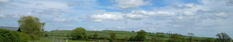
We decided to explore across the other side of the river Tweed, which we could see from Berwick Pier. This side of Berwick was not as busy and although we were now walking a seemingly narrow street – this actually known as “Main Street” .   A main street not as you would have expected full of shops – it mainly small residential cottages.

It was not long before we discovered LS Lowry had trodden these very streets….  He had used his pencil and imagination to create a set of images about the ordinary life on the Main Street of Berwick. As we wandered down the road, we realised this had once been a very busy quayside had been cleared for redevelopment…. I am unsure if this was a good thing or a bad thing – but there is now a beautiful view across the river Tweed.

From 2011 – 18.05.2011 – Berwick Upon Tweed – Spital Walk

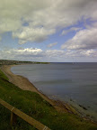
Walking along the quayside, it was obvious that this beautiful shore was very inspirational to Lowry and I wouldn’t be surprised to many more.  We continued past the Lifeboat Station, which had been in operation in this position since 1834 – although in it’s history it had been relocated at least once.

As we walked along we did notice a huge stone bridge, across the other side of the street which looked very odd, since it was not used for anything and therefore completely unnecessary – an old train branch line perhaps? But we would need proof of course!

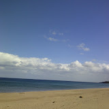
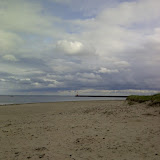
We did not continue down the shoreline, as we were unsure if the coast path continued around some old warehouse buildings that we came across.  It did not look very inviting, so we decided to walk along “Spittal High Street”?   Eventually we found a footpath which led us to Spitall Promenade.     I have said this in many blogs before, and I won’t hesitate to mention it again – I wish I had brought my bucket and spade!  The Spittal Sands are fantastic – definitely the place for a sandcastle competition and some Punch and Judy on the beach :-).

From 2011 – 18.05.2011 – Berwick Upon Tweed – Spital Walk

It seems that Spittal Sands was a very popular Victorian Holiday Destination.  It was popular with people from London, Europe and Scotland.   The Holiday Camp and Caravan Park that opened in 1945 and 1950 respectively attracted a huge number of tourists to the area making this a very popular resort.  Unfortunately, with the closure of the Kelso branch line in 1968 – this was the beginning of the end of this wonderful holiday resort – so the predicted future holiday destination by the Victorian’s was abruptly ended by Dr Beeching 😦 .  This resolved our mystery bridge – it was an abandoned branch line after all.

It seems that Lowry spent a lot of time at Spittal sands – not only enjoying the sun, sea and sand – but observing and painting the area too.   Clearly, he enjoyed the prom – a couple of his paintings “Girl In a Red Hat on a Promenade”, 1966 and “Man Looking Out to Sea”, 1964 are painted on Spittal Promenade. We decided to depart the seafront to enjoy some cliff walking. It gave us chance to see the view right across Spittal Sands and to Berwick Pier

From 2011 – 18.05.2011 – Berwick Upon Tweed – Spital Walk

We were now part of the “Northumberland Coast Path”.  The entire path is 64 mile (~ 103 km) long – but we were not going to walk all of it!   The direction we were walking was towards Seahouses, where you can pick up the boat to Farne Island – also known as “Holy Island”.  I doubt somehow we were going to get that far.

This part of the coast path was quite strange.  The Great North Eastern Railway runs alongside the cliff, which does feel quite ominous – I found myself hoping that a high speed train would not come rushing past at any moment.    I had noted when I walked along the cliffs towards West Bay how I was not keen on being on windy cliffs – on this occasion we definitely  felt like were being blown away! We decided to abandon the cliff top walk for the day, since the wind got the better of both of us, which was a shame, as I would recommend this walk , despite the high speed trains ( shame it wasn’t a lovely old stream train – but then again I am biased!!) We turned back towards Spittal.

We passed Cow Road – although I am not sure why this was so called? Perhaps farmers used it for herding cows? That is logical! However, from a local map in 1828, the Old Berwickhill Colliery was located at the end of this road which does not really indicate farming but mining!  As we walked further in, we were confused to find ourselves confronted with a sign saying “Welcome to Berwick Upon Tweed” – we did not even know we had left it! 😀

From 2011 – 18.05.2011 – Berwick Upon Tweed – Spital Walk

As we walked through the small high street,  it really did seem like it was a lovely little village. I could see why the Victorians would have enjoyed this as a Holiday Resort. In fact, one of the biggest reasons the Victorians enjoyed Spittal so much, was the “Spa Well” that was located in there.   The Well itself was built up in the late 18th Century and has been identified on a 1837 map as “Spaw Well”. This was one of the major reasons that in the early Nineteenth Century Spittal developed as a resort.  A “New Town” was built up to attract visitors for sea-bathing and to drink the waters from the Well. The spa was valued as a source of iron, lime, magnesia and sulphate of soda.

We left the high street to sit on the prom – and watch gannets dive into the sea for fish.  A great sight to see.  Gannets  have made a home on Bass Rock – North Berwick – and obviously found it that it was worth the flight to Spittal for some great fish!

We continued our walk along the bay and found evidence of Spittal’s fishing industry. All indications seem to me of Salmon fishing – but I have found that the smokehouses and the fishing that was done in Spittal seems to have been herring fishing and not Salmon – unless anyone can correct me?

Passing by the mouth of the Tweed once again, and leaving behind the beautiful Spittal Sands, we crossed the Old Bridge back into Berwick Upon Tweed.   We had picked up the Lowry Trail again.  We had stumbled across “Bridge End” this was originally hand drawn by Lowry and subsequently committed to canvas in 1938. When I was comparing the painting to the buildings that still survive today – it felt that not much had changed between 1938 and 2011 ! Amazing…

Leaving Lowry behind, we decided to continue our walk along the Tweed River. Amazingly this is still part of the “Northumberland Coast Path” so we never really left it! This walk was to take us under two bridges. One was a road bridge – the other a railway bridge. Why is that significant? The railway bridge is actually quite stunning to behold. It looks quite an engineering feat. The “Royal Border Bridge”, as it’s known, took over 3 years to build, 10,000 man days and over 40,000 bricks to complete!

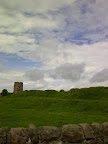
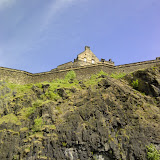
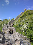
As we passed beneath the bridge, we had found part of Berwick Castle. One of the most notable things about what is left of the castle are something that looked like stone stairs. These “Breakneck Stairs” as it is known – was a wall built by the English and modified to have holes cut out for artillery men to fire handguns at the enemy!

From 2011 – 18.05.2011 – Berwick Upon Tweed – Spital Walk

Sadly there is not much left of the castle since it was mostly demolished due to the building of the railway 😦 which is a shame. The castle has a rich history of fighting between English and Scots – it was first reputably rebuilt by Edward I. The Victorians must have felt the castle was not of use and removed it as the railway was more important!

The path takes an odd turn here and walks along side the castle uphill and no longer along the river Tweed. It brought us out at Berwick Upon Tweed Railway Station. We continued along Northumberland Avenue to find the coast again – a nice way to end a days walk – with an ice cream and a short walk along the coast path and stare out at the clear and beautiful North Sea.

All the photos for the days walk are as follows –

2011 – 18.05.2011 – Berwick Upon Tweed – Spital Walk

<><

Berwick Upon Tweed Walk – 17.05.2011

The day started out with a gentle stroll along the coastline.  The tide was out – showing how rocky the bays really were – I must admit I did want to go rockpooling!  What a great place to find out what creatures were living along the shore line – no doubt crabs and the like would have been thriving amongst those rocks! As we made our way around the path we discovered there some steps down the beach – what a temptation to be distracted from our walk!

From 2011 – 17.05.2011 – Berwick Upon Tweed Walk

We continued to amble along the windy cliff top and enjoy the rest of the views. I must admit that because the path was alongside a caravan park, I must admit it had been reasonably well kept. Certainly made I nice change from some of the other coast paths that I have walked in the past!   It was not long before the path hit a junction – Go along the Coast line towards Marshall Meadows or alongside the Caravan Park and Golf Course. We decided to take our walk inland – so we could explore the town of Berwick Upon Tweed instead.

Berwick Upon Tweed is surrounded by large imposing stone walls.   We were faced by the Berwick defences which had been built in the Elizabethan times, to keep out the Scots and the French from England, and still standing today. I was a little bemused to see a small archway which led into the main town high street… Apparently the original gateway was a lot smaller, in fact it was only one cart wide – with a drawbridge and moat – all in the name of controlling the way in and out of town! It still felt like this small archway may and walls still could frighten the odd tourist away!  

Walking along the High Street, we walked passed Berwick-Upon-Tweed Town Hall – which is a lovely example of 18th Century architecture, to find a hidden a path which led us to the “Berwick Upon Tweed Ramparts”.

The Berwick Ramparts had been a massive town fortification. They had been ordered to be built by Queen Mary 1, during the 16th century – to keep out the Scots and the French. These style of town fortifications are unique in Britain.   Although we did not investigate the whole of the complex the total a size of the ramparts is one and a half miles in length (~2.41km).   This amazing “fortress”, which I think it I would call it, must have been an amazing sight to behold. A complexity of tunnels, bastions and artillery storage rooms? I presume that is what they were – I am surprised anyone could find they way around the place let alone actually capture it!

From 2011 – 17.05.2011 – Berwick Upon Tweed Walk

As we turned the corner, I was astonished to find yet another Millennium Beacon It had been placed on top on one of the ramparts structure! (at least I think so anyway – Judge for yourself!) So this was my 7th Beacon 🙂 Purfleet, Wemyss Bay, Hainualt Country Park, Doniford Bay ,Canvey Island and Hastings  have all the other beacons I have found 🙂 I think I have collected quite a few!  The beacon is placed just above the “Windmill Bastion”  which although was built in 16th Century,  was used right up until the beginning of the 20th Century.    These structures were used for volunteer soldiers to defend the coastline against any enemy landings…

Leaving the ramparts behind, we found the Berwick Upon Tweed Barracks.   These Barracks had been built between 1717 and 1721 – England’s first purpose built infantry barracks in the country.  These had been designed by Nicholas Hawksmoor – who had worked alongside Christopher Wren on projects such as the Royal Chelsea Hospital in London, Hampton Court Palace and St Paul’s Cathedral.      These barracks deserved more time than we could give them, so we did not visit them on this occasion.  We did take an opportunity to visit the church opposite.  

This was the parish church  of Berwick and in fact is the only example of a Church which had been built during Oliver Cromwells reign.   The church was commissioned by Colonel George Fenwick – Cromwell’s Governor of Berwick , his memorial stone in the church reads “a good man is a publick good”.  This church is very impressive piece of architecture and I would recommend if you are ever visiting Berwick to wander around the church – I was most impressed with the outside of the church and the largest Sundial I had ever seen!

From 2011 – 17.05.2011 – Berwick Upon Tweed Walk

Leaving the church behind, we wound our way towards Berwick Quay. It was lovely to see some swans gliding along the river. These Berwick Swans are quite famous in their own way. In fact Berwick is home to the second largest mute swan colony in Britian! Apparently there are over 200 residents in the colony! I must admit we only spotted 5…

We then made our way to Berwick Pier. Not a the Seaside Pier that I spoke about in Hastings! A pier that hosted a light house to warn ships about the rocky coast ahead! The pier did seem awfully long (in fact it is 1/2 mile long (~0.80km), but the walk was worth it. We found that this was part of the L.S Lowry trail. Berwick Upon Tweed was a popular holiday destination for the painter – and inspired many of his paintings….

We walked back down the pier and onto the nearby meadow. It was not long before we discovered another L S Lowry information hot spot. It seemed that the little shelter, which was on the meadow, which was overlooking the sea, Lowry had used for his painting called the The Pavilion. The painting had been re-enacted by the local residents/school to when the shelter was refurbished. We were to discover a lot more of Lowry’s painting all over Berwick – it is so nice to see paintings come alive…

We took a turn for the beautiful and white sandy beach – I would have taken time out to chill out on the sand if we had more time but sadly we didn’t 😦 . Although we did enjoy watching the birds dart amongst the cliffs! I think they were nesting up there – looked a little risky to me! Leaving the beach behind, we walked past the pier, to discover another Lowry pencil drawing of the Berwick Pier and Lighthouse – I certainly could imagine sitting there with my sketchpad just like Lowry I definitely couldn’t blame him!

It was time to finish our walk for the day – all the photos for the days walks are as follows –

2011 – 17.05.2011 – Berwick Upon Tweed Walk

<