Monthly Archives: September 2012

Bleadon – Weston Super Mare Walk – 08.09.2012

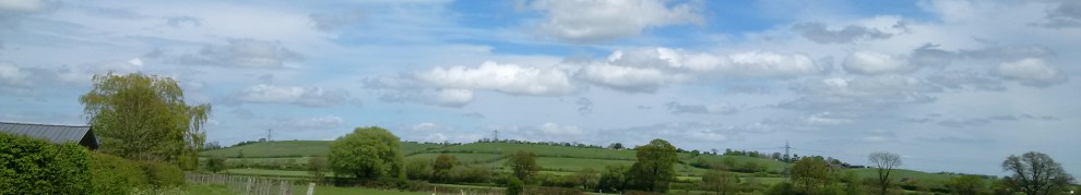
From a quaint and quiet village to the contrast of a bustling town of Weston Super Mare, which is where we were headed. Most of the route for the day was along the roadside, which was as I have said before, is not my ideal walking conditions. However, as we were not in familiar territory and we were lacking an O/S map walking along the roadside seemed the logical way to reach our goal! The views along the way did not disappoint 🙂

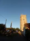
We were tempted off our route with one footpath, which would have taken us across lush green fields to another village and Church for us explore. We, however, continued on regardless with our chosen route into Weston. We finally reached the end of this extremely busy road, when I spotted a sign which seemed to be hidden away, for a Bed & Breakfast. Why would would a Bed & Breakfast be of interest? Well the entrance was a gothic building which reminded me of the buildings which I had seen in Stanmore and Gunnersbury Park.

In fact the Bed & Breakfast was “Uphill Manor”, but when it was built in 1805 it was known “Uphill Castle”. The title “Castle” does make it sounds rather grand, I would have like to have seen it! The building was purchased in 1853 by Thomas Tutton-Knyfton, he made additions to the building including a new drawing room, octagonal hall and tower in the victorian “High-Gothic” style. The wallpaper which was hung in the drawing room, was designed by Augustus Pugin during the 1840s, was also used in the Palace of Westminster. The Manor remained in the same family until the early 1990’s when it was purchased by the current owners who use it for B & B 🙂

From 2012 – 08.09.2012 – Bleadon – Weston Super Mare Walk

As we turned the corner from the Manor house, we could see the see in the distance beyond the Golf Course. I have come across quite a few Golf Courses in my time but most of them have had walking paths across them. Unfortunately, this one didn’t so we were unable to walk across the links to the seafront.**I have now been informed by a local source that there was footpath across golf course to beach opposite to the entrance uphill manor adjacent to the Golf practice field & bluebell wood, shame we missed it :-(** The Golf Club has been in Weston since 1892 and is still going strong today. In it history it faced the challenge of a offering a separate links for women, as their course should be “perfectly separate from the men’s”, I am not sure how that would be received in this day and age 🙂 It does go to show how sport and the attitudes have altered over the years!

We continued on past the Golf club to pass a lovely Church. Actually, it was not a church, the building had been converted into use of flats. I am still struggling to find out what the original use of the building was? I can see that a chapel was attached as there was a bell which had been removed from its housing and the stained glass windows were still intact. However, the rest of the building looked like it may have been either a school or convent? If anyone would care to enlighten me I would be very grateful!

Our route was to finally take us off the road, to the large Sandy Seafront! Weston Super Mare’s extensive Beach was rather a joy to walk along on a September day 🙂 , it was so lovely and warm, I was able to indulge by walking along in bare feet and feel the sand beneath my feet. However, I did not go as far as paddling in the sea on this occasion, not because the sea may be cold, but because the sea was quite far out. Weston tides have a reputation of having a very *large* tidal range and when the tide is out that means the sea goes out quite a long way! Although Weston has a fantastic sandy beach, it has earned the title “Weston Super Mud” because of the lack of sea due to the tide! I did not want to venture out and experience any mud myself!

From 2012 – 08.09.2012 – Bleadon – Weston Super Mare Walk

As we strolled along the Sandy Beach we came across a Beach Volleyball net. I highlight this, because if anyone is interested in training for the Olympics in Rio 2016 or even the 2020 games this the place to do it 🙂 Don’t panic if you don’t know the rules they were available on the wall near the net! Wandering away from the Beach Volleyball, we found the beach had the more traditional activities that are associated with the seaside, donkey rides and swings 🙂 . Although Donkey riding is not an Olympic Sport like Beach Volleyball, it is great to know that the Gold Medalist and Paralympic Champion Lee Pearson started out his amazing career on a Donkey!

In the distance I spotted an unusual Shaped Elephant? Actually it was a sculpture! I was unable to tell exactly what it was, but it did look good! If we had time to investigate further the sculpture was actually part of the “Weston Sand Sculpture Festival”. The festival has been on Weston beach for the last 6 years and has been visited by approximately 250,000 people! It certainly looks like we missed a treat, as these sculptures were more than just the average sandcastles! It was here we decided to leave the beach, to join the seafront as we thought we may take a stroll along Weston Super Mare’s “Grand Pier”

The “Grand Pier” was built and opened in the early C20th, when it had a large pavilion to house entertainment such as ballet, plays, music hall and even boxing. The Pier has suffered at the hands of fire twice in its life time, once in 1930 and in 2008. In 1932 the pavilion was rebuilt to house a funfair rather than a theatre and the pavilion was restored after the 2008 fire and reopened once more in 2010. We decided to visit the pier later that afternoon as we wanted to explore Weston further after we had a break for some tea!

Feel free to browse through the photos for the first walk of the day –

2012 – 08.09.2012 – Bleadon – Weston Super Mare Walk

<><

Bleadon Village Walk – 07.09.2012

We were taking an evening stroll to enjoy the explore the surroundings. Our walk was to take us along a country lane, footpaths and eventually led us to “Bleadon” village. We had already walked past “St Catherines Inn”, but we both agreed it was much to early in the evening to contemplate having a drink! As we continued along the lane it seemed that most of the paths, which came away from the lane did not seem to be very inviting. Eventually we discover a footpath we were able to walk along 🙂

The path that we had found was part of the “West Mendip Way”. The way is ~28 miles (46.4km) in total and although we were tackling a tiny portion of the route that evening, it is something that could be explored in a future walk. This part of the path goes through a small private road, which at first I didn’t mind, until a local decided to drive past us 😦 It was quite disconcerting in my opinion, so I was glad when the path finally joined up a with a small gravel footpath which ran next to a large field. It did not give us not the most exciting views, but it was certainly more enjoyable than walking along the roadside. The path was reasonably short in length and it was not long before it brought us out into a small lane. Suddenly we were faced with a choice to either to climb up to the top of “Bleadon Hill” or to walk around the village. We chose the village and felt we would save the hill for another time.

From 2012 – 07.09.2012 – Bleadon Village Walk

On the way up the hill there was yet another pub, which again we didn’t think our walk quite justified visiting, so we passed it by. We started on the descent, and I will say that the first impression of the Bleadon village was seeing the impressive Stone Church which seems to dominate it, in fact A A Milne wrote something about it –

” Between the woods in folded hands
An accidental village stands,
Untidily, and with an air
Of wondering who left it there
Four square upon a little hill
The Norman church is Norman still;
And on the winding road below
The ageing houses come and go,
Grey faced and wrinkled, in a long indented row.”

A A Milne

“The Norman Church” 1948

A A Milne refers to St Peter & St Pauls Church as the “Norman Church”, which as the Stone Church it is. However, Church History suggests that there is good reason to believe that there has been a Church since Anglo Saxon times before the Normans built this beautiful Church. Saxon Churches were often dedicated to two Saints and this was common practice in Saxon Churches, with St Peter & St Paul sharing the same feast day, it is highly likely that this church in roots in Saxon History. Indeed, evidence still remains in the Church, if we had been able to venture inside a little stone angel is still visible high in the arch on the north wall. It was a shame the Church was shut as I would have liked to have been able to walk around it!

Just outside the Church was a Cross, which I presumed was a war memorial, I was wrong. This cross originally marked the boundary of the Church and was built during the C14th. This Cross was built during a time when “Black Death” had arrived in the Country, other similar Crosses had been erected throughout Britain. It seems these were built as a sign to ward off the terrible “Black Death”. Later in its history, The Cross has been moved from it’s original position in the Church grounds to just outside the Church and has also been rebuilt after it was struck by lightning! The cross has also been a place for people to sell market goods and to preach, a much nicer history than hearing it was used to ward of the “Black Death”!

From 2012 – 07.09.2012 – Bleadon Village Walk

As we gazed across the other side of the village, we saw a tiny cottage with some iron pumps standing outside it. Both of these pumps were the main source of water for the village right up until the 1940’s when water was finally piped into the village. The larger pump was used for carts and containers, the smaller one for pedestrians. Our walk proceeded too take us out of the village and out once more on to the road. The route was not too bad as it ran parallel with a small water way. I thought that this was the River Axe, but it was much too small! In centuries past Bleadon had a port on the River at Lympsham Wharf and the Axe provided the main trading route until the arrival of the railway in 1841. The last boat that used the wharf was in 1942.

As we continued along the road and past the Bleadon Stores, we found a footpath which we had not noticed previously this was in fact another part of the West Mendip Way. Unfortunately as we started to walk this we realised we could not continue as we did not have our walking boots and could not negotiate the muddy areas that we were suddenly confronted with 😦 . We carried on our walk on the opposite side of Bleadon Village, to see what we could discover. Our walk took us to the fields behind the Caravan Park, where we were rewarded with a beautiful evening Sunset, it was showing me that it was not long before we needed to end our walk for the day. I will admit that there did not seem to be any way markers for any public footpaths, so we could not venture far, but the views and the sunset definitely made this a part of the walk worthwhile. We discovered that that these part of the fields seemed to have been maintained for dogwalkers from the Caravan site, but I could be wrong and someone could kindly correct me!

At this point we finished our short evening walk, which we rather enjoyed. The weekend was lined up to have a lot more walking in store so we thought we wouldn’t wear our feet out too quickly! Please feel free to browse all the photos for the evening walk –

2012 – 07.09.2012 – Bleadon Village Walk

<><