Monthly Archives: April 2013

Ruislip Manor – Ruislip Lido Walk – 01.04.2013

Arriving at Ruislip Manor, we were anticipating a large stately house to home into view, but this was not the case, instead we were greeted by a brightly coloured parade of shops. Our walk was to take us alongside Ruislip Manor Underground Station, onto the High Street and then into Pembroke Road, leading us to the village of Ruislip. Unfortunately, we had arrived when roadworks were taking place at the junction of Ruislip Station, normally this would not trouble walkers, but in this instance it did :-(, as it was a bit difficult to cross the road! However, once we had successfully crossed over, we were on the high street. At the top end of the road the buildings seem to no longer seem to be the usual modern shops but they were much older in character. I was particularly struck by an old water pump that stood outside one of them. The water pump was originally sited in the central roadway, but in the 1970’s, as a result of increased traffic it was moved to it’s new location.

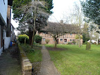
Walking a bit further along, I was rather taken by a small wooden archway, which seemed to belong to the local Parish Church. Taking a walk under the arch, I was able to see the Church of St Martin’s. The church has a long history, although the outside flint walls date back the C13th, some Roman tiles have also been found there! The village of Ruislip is listed in the Domesday Book when a priest is known to have held over 40-60 acres of land, possibly relating to St Martin’s Church. The Church has been altered throughout the years, during 1870, a large restoration project was carried out on the building by Sir Gilbert Scott and Ewan Christian. Both of these notable architects had been behind large developments such as the Grand Midland Hotel / St Pancras Station and National Portrait Gallery. The Church resides near a few other older buildings, all of which would have formed the original core of the Ruislip’s village square.

From 2013 – 01.04.2013 – Ruislip Manor Walk – Ruislip Lido Walk

We crossed over from the old Village, and found the “Manor Farm Heritage Site”. Just to the side of site was a large duck pond, throughout the C16th the pool was more commonly known as the “Horse Pond”. A blacksmiths, which has long since gone, once stood nearby making the pond a hive of activity, the smithy often collecting water to cool the furnace. Horses were often brought to the pond to be washed down and to drink, I can imagine the whole place would be have been buzzing with activity with the toing and froing from the blacksmiths! This is so different from the “Horse Pond” we had found in Hampstead. These days the pond is very serene in comparison! Beyond the pond we stumbled upon the sign for the “Motte & Bailey Site”. Ruislip had it’s very own Castle, courtesy of the Normans, built in C11th, probably as a town fortification. Although the structure would been created out of wood rather than stone, a little different from other Castles I have encountered. It was not mentioned in the Domesday book, so I am not sure how long the “Motte & Bailey” actually lasted, but the site where it used to stand is still quite evident.

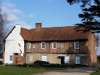
I turned away from the missing castle to spot a set of wooden buildings which seemed to be still in use. The first one was known as “Little Barn”, which was alongside the “Great Barn”, both of which were built in the C16th, to store crops and produce when they were part of Manor Farm. The smaller structure was converted into Ruislip’s public library at the beginning of the C20th, what a change in usage! On the other side from the barns, we could see a piece of public art that had been installed above the small stream. It is simple artwork of pieces of Willow which have been crafted around clay pots representing flowing water and earth together, hence the Anglo Saxon title “Ea Eard”, which means exactly that. Around the corner from the stream we discovered Ruislip Manor House, the one we had been expecting to find when we first arrived.

From 2013 – 01.04.2013 – Ruislip Manor Walk – Ruislip Lido Walk

This great house was constructed at the beginning of the C16th, although at first glance I could see that the house has been radically altered over time. This is particularly noticeable with the C18th Sash windows, but nonetheless an impressive site. This was not a nobles home, as I thought, but it was built by Kings College Cambridge. When the College felt that they required more comfortable surroundings for there visiting dignitaries to stay, they commissioned for a manor to be constructed for them. Not only did the college use the site for dignitaries, but they used the site for the college farm. The house was also used for some sort of manorial court, sessions were held here right up until the C20th. Just beyond the House, we joined a small footpath, taking us past something looking like a huge bunch of brambles. In fact this was known as the “Ditch and Bank”, which had been the “Saxon” boundary of the village of Ruislip. Prehistoric Flint tools and clay pottery have been discovered here when excavations were carried out, showing that the area of Ruislip has been populated for a very long time!

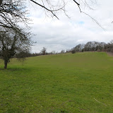
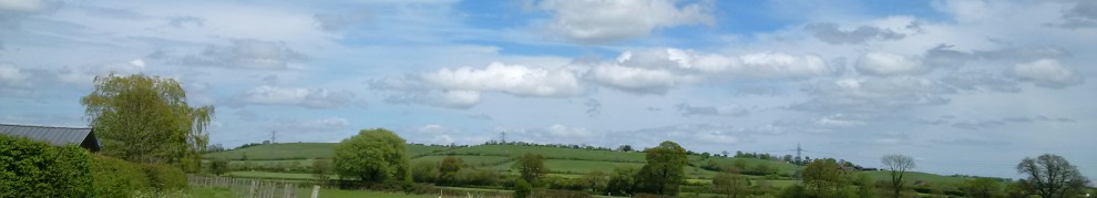
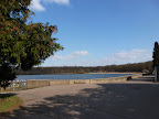
The pathway led us out onto a “Flood Meadow” of the River Pinn, which was not overly muddy or flooded whilst when we encountered it :-). As we reached the small river, we discovered that we could have joined another trail known as the “Celadine Route”. The path would have taken us along the river Pinn, but we decided to save that path for another day :-). At this point we took to the pavement, passing by the “Hillingdon Trail”, but again we left the footpath for another walk! Our route had eventually brought us to round to “Ruislip Lido”, whose blue waters really were sparkling in the spring sunshine :-). It did not resemble the lido’s that we had stumbled on in our previous walks, like Barking and at Margate which had been neglected and no longer used. The Lido itself did not look like a traditional looking lido that I would have expected, but this is due to the Lido being created from the “Ruislip reservoir” as a means of Water Supply in C19th. Therefore, it was its original intention was nothing to do with leisure facilities. However, the lake was never used as a water supply and instead attracted many day trippers and wildlife alike, by the early C20th the Grand Union Junction Canal Company, reopened the lake as “Ruislip Lido”.

From 2013 – 01.04.2013 – Ruislip Manor Walk – Ruislip Lido Walk

As we turned the corner we came across an enormous building, which incorporated the “Ruislip Woodlands Centre” and the “Waters Edge Pub”. At first I thought that the building had been there for quite a number of years, but I was mistaken, as the pub had been built to replace the original Art Deco cafe built here in the 1930’s. Unfortunately the cafe was burnt down quite a number of years ago, shame it would have been a lovely sight to behold I would imagine! We did not stop for a drink to discover if it served a decent tipple or two! Therefore, we carried on our walk, whereby we discovered a electric locomotive. The lido railway has been in existence since the mid C20th, when it was built as part of the many attractions of the newly opened Lido. The line only seemed to suffer during the mid 70’s when it was sadly shut down, it seemed to be part of the Lido’s own decline. A keen bunch of Volunteers formed the “Ruislip Railway Society Limited”, who since that time have bought new engines and have extended the line to double it’s original size!

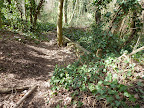
Our walk was to partial follow the Lido Rail line, through the open woodland areas. It was not long before we caught up with the first rail platform “Haste Hill”, although it seemed to be permanently closed. It did feel quite strange to stumble on what felt like an abandoned platform on a miniature railway! From open scrub land, the path suddenly became enclosed by trees, but it was not all that bad as the darkness was broken up by the sunlight shining through the branches. Trees were still quite bare and there were still plenty of brown leaves strewn on the ground, which made the walk have an autumnal feel rather than spring. However, we were able to gaze over the lake through a convenient gap in the wood and the warmth of the sunshine soon reminded us that it was definitely spring! High up on one of the trees was a a sign “Julierpass”, which seems to refer to a Swiss Mountain passing place, I am not sure why the Ruislip Lido Railway Passing Place has the same name?? It was not long before we reached the end of the line and quite a few construction works as the station is currently under renovation as is the whole area, but it was still very busy as we had reached the piece-De-resistance of the lido, the beach.

From 2013 – 01.04.2013 – Ruislip Manor Walk – Ruislip Lido Walk

On a lovely sunny spring afternoon, it was so nice to be able to walk on the beach next to still waters of the reservoir. I really did want to feel like I was on holiday, therefore I was not surprised to learn that Cliff Richard’s film “Summer Holiday” was filmed here. With the reservoir so calm, I can see that people would have been keen to boat on the lake, but in 1958, a ship sunk here! This was the Titanic, when they filmed “Night to Remember”. Apart from Boating, it seems that Water skiing was popular on the Lido, in the Movie, “The Knack” in 1965, with Charlotte Rampling and Jacqueline Bissett used the reservoir for water skiing stunts in part of the film! A Ruislip Water skiing Club exists today and was founded by the Dr Who actor Jon Pertwee! Strolling amongst the sand with a hot drink, it really was wonderful. I had a glimpse into why the Lido was so popular all those years ago on such a warm day!

We wandered further around the lake to the other side to complete the walk around. It was here we decided to leave the lido behind and walk back into Ruislip, following the roadway. We eventually crossed over another part of the River Pinn, which seemed to wind it’s way lazily through the woodland. We eventually reached the northern end of Ruislip where I spotted “The Duck House” Inn, which is the oldest in tavern in Ruislip, which was built in C17th. However, we were unable to stop for a drink 😦 as it was here we ended our walk, so we could go back home for spot of lunch.

For all the afternoon walk photos, please click on the photo below –

2013 – 01.04.2013 – Ruislip Manor Walk – Ruislip Lido Walk

<><

Mill Hill Broadway – Mill Hill Village Walk – 29.03.2013

Setting out from “Bunns Lane, Mill Hill” we both expected to be greeted by the wonderful smells of hot cross buns and fresh baked bread half way along the road. Sadly we were disappointed we could not find any bakeries whilst we were walking :-(. Instead, I think that the name “Bunns” derives from a family name, when the land was bought from the Bunns Estate, rather than anything edible which is a shame 😦 . If anyone has any other ideas, please comment. Just down the lane, we came across a brick built bridge which did not seem to cross anything particular. Therefore, our curiosity got the better of us, so we decided to investigate.

Crossing over the road, we found that the could explore the bridge further, as footpath ran next to it in“Lyndhurst Park”. Upon entering the park, we felt that it was divided into two distinct areas, an open grassy space and a wild woodland, which was behind the bridge. This expanse of land seemed very difficult to walk in as it was very overgrown and there was no footpath to walk along. We were still able to examine the bridge a bit more carefully despite it being a little tricky to get to. We soon discovered that this bridge had some of it’s archways bricked in, which indicated that it had been part of a railway at some point. As we walked further along we noticed some odd looking concrete poles which seemed to be carry some sort of electricity cables at some time. It seemed that we had discovered a stretch of land which had been part of the underground, which had been closed quite some time ago.

Some of the difficult parts which had been trying to walk on had actually been the original platform of a disused Underground Station, Mill Hill (The Hale), which was officially closed in 1964. The route, which went from Mill Hill East to Edgware, had been in existence since the late C19th. During the early C20th the line was to be upgraded as it was seen to be an important interchange with the overground station in Mill Hill and was closed temporarily to carry out the upgrade. Despite the alterations and expansion to the station, the line was never officially reopened to passenger traffic, therefore only Freight trains ran on the line until its closure. The small part of the closed line we had found was to be integrated into a walk but instead became a nature reserve.

From 2013 – 29.03.2013 – Mill Hill Broadway – Mill Hill Village Walk

We left “Lyndhurst Park” behind and continued to proceed down Bunns Lane. We passed by “Flower Lane”, which I naturally assumed came from the beautiful looking flowers that were in the surrounding park or perhaps from Flower Market that once stood here. Instead, “Flower Lane” derives it’s name from Sir Charles Flower Bart a former Mayor of London, who once lived in Mill Hill. Much further along the road we passed by a large house which had the word “Laing” on it. The house once belonged the construction company “Laing”, which was run by Sir John Laing. Laing Construction moved their offices from there small beginnings in Carlisle to Mill Hill, where they grew and are known for constructing Coventry Cathedral which had been destroyed in the Second World War, Regent Park Mosque and building the M1.

Past the Laing House it seemed like the next section of our walk was mostly pavement walking. Our route took Devonshire Road, where discovered another bridge which crossed neither railway or river, but a muddy trail instead. We both felt that this was probably another section of the abandoned tube line we had found earlier. Once we had crossed over the road we found that were able to join the footpath that was beneath the bridge, using the concrete footway from the road. Unlike the previous section of deserted line, which had been left to nature, this part had been into proper footpath. It was clear to see that it had been well used as we could see quite a few hoof marks where horses had been treading this way before! The only disconcerting part of this walk was when I stumbled on a concrete sign stating “cable 32,000 Volts under”, which I was rather I hoped would not be the case as that is a lot of electricity to walk next too!

With the trail being particularly muddy and the trees surrounding the trail it really did give us a feeling of no longer being in an built up area. The only clues that made us feel that we were in urban place were the brick bridges that still spanned the old line. The route seemed to end abruptly at one of these bridges, which is in terrible state and I am really surprised it is still standing as the supports have terrible cracks in them. I presume that the recent weather has not helped its condition and we could still see evidence of this when we saw some huge icicles hanging from it! As we were leaving this section of the line behind, we discovered the path had been incorporated into one of “Brents Leisure Walks”. As we turned to cross the bridge, we had a real surprise, despite the state of structure underneath it, the path had been freshly tarmacked. Personally I did not feel very comfortable crossing it!

From 2013 – 29.03.2013 – Mill Hill Broadway – Mill Hill Village Walk

Somehow our walk rejoined Devonshire Road, which was to take us to Holders Hill Circus. I cannot find out much about the name, which is shame, as I was hoping to find something out something on a Circus with Clowns and Acrobats which had been held here in the past! We turned uphill here to walk towards Mill Hill Village. En-route we passed by Mill Hill East Station, which is quite small. The station opened in the C19th, when it part of the Great Northern Railway, but it was not until 1941 that Mill Hill East became part of the Underground. This was when a shuttle service was provided to Mill Hill East in order to serve the local barracks. The Mill Hill East branch did not suffer the same fate as the rest of the line with the track closures at the early C20th. This was after the scheme named the “Northern Heights” which have taken the Northern line beyond Edgware did not materialise.

Our walk was now to take us up Bittacy Hill, where we passed by “Bittacy Hill park”. It was nice to see daffodils blooming there, despite all the terrible spring weather that we have been suffering. We finally reached the top of the hill, where we treated some great views over London, looking carefully we could see St Mary’s Church, Harrow and Wembley Stadium. As we continued on our journey, it was not long before a scary and daunting building loomed in front of us. This art deco building is the “National Institute of Medical Research”, designed by Maxwell Ayrton who designed the original Wembley Stadium and built during the late 1930’s. It really does feel like it should be in a horror movie, I don’t think it has been used for such a film. It has been used in the movie “Batman Begins”, when the exterior for the “Arkham Asylum”, somehow I am not surprised!

As we continued along the Ridgeway, we could see on the opposite side of the road a church, but there did not seem to be any information about it. It looked very odd as it was attached to a house, if anyone has any information I would like to know. The road then took us onto “Mill Hill Village”, which surrounded a large pond. As we started to walk around the village, we found it bereft of shops, which seemed very odd to me. We found ourselves strolling along the “High Street” and passing by residential buildings with names like “Old General Store”. Nowadays, Mill Hill village relies on shops outside of the village centre! Upon leaving the High Street, we spotted “Rosebank Barn”, which had been a Quaker meeting place in the mid C17th. Just along the road we discovered Plaque to the Botanist and Naturalist Peter Collinson. He was Quaker and it was more than likely he attended the meetings at Rosebank Barn whilst he lived in Mill Hill. Collinson, although a Cloth Merchant, studied plants and with his overseas trade was able to obtain many seeds and plants internationally. He had regular correspondence with Benjamin Franklin as was a supporter of the Philosophical society, Collinson was also one of the governors of the London Foundling Hospital.

From 2013 – 29.03.2013 – Mill Hill Broadway – Mill Hill Village Walk

We proceeded on our journey, passing by Mill Hill school and as we did I caught sight of the “Patrick Troughton Theatre”. Nothing unusual about a theatre being named after a TV star, but Patrick Troughton attended this school as he was born and bred in Mill Hill. The Theatre was recently renamed in his honour and apparently as part of the celebrations, whilst a production was being put on, a Dalek from the Dr Who series came to watch! Just across the road from the school I spotted a plaque on a church, so I immediately crossed over to read the inscription. The church had been built by William Wilberforce, who was one of the key figures in the abolition of the slave trade. I was aware Wilberforce lived in the area, when we walked this way before, but I was not aware of the churches existence. Apparently, he undertook to build this church at his own expense, as unfortunately there was not a nearer church that he was able to attend. Sadly the chapel was not consecrated until Wilberforce had passed away so he was never really able to attend the church he had commissioned 😦

Coming along the road we came across a large pond, known as “Sheepwash Pond”. The name “Sheepwash pond” derives from when farmers used to wash their cattle and sheep through the pool when they were en-route to the Smithfield market in London. I am pretty sure that the sheep and cattle would have preferred to remain here than carry on their journey! The creation of the pool was from when Sir Charles Flower dredged the site for gravel for a local toll road, nothing to do with sheep at all! Although we can hear the sound of sheep today as “Belmont Farm” lays just behind the pond, which we had discovered a sign for in one of our previous walks. It was a shame we did not get time to visit as it was just so late in the day :-(.

Passing by the pond, we walked on by Hammers Lane, where we discovered “Mill Field”. It is here that a windmill once stood giving the whole area the name “Mill Hill”. It is certainly a great shame that the windmill is no longer around to admire 😦 . The field certainly commands some amazing views as it was quite high up. It is a great position for a mill, as on a gusty day I can just imagine the sales whizzing around! It was here we rejoined our previous walk which we was to take us down Highwood Hill, past St Josephs College, eventually back to Mill Hill Broadway where we ended our walk for the day.

The route for the our walk was as follows. Please click on the photos below for the photos from the walk –

2013 – 29.03.2013 – Mill Hill Broadway – Mill Hill Village Walk

<><