Monthly Archives: May 2012

Fishers Nature Reserve – Bushey Mill Lane Walk – 20.05.2012

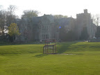
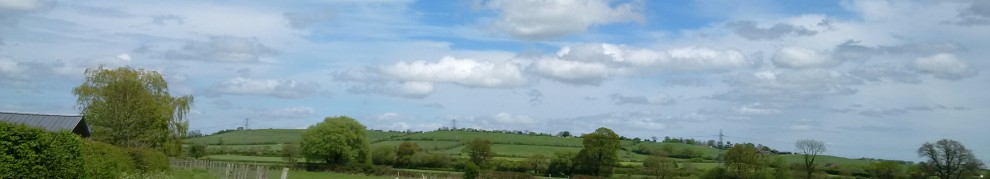
This short Sunday morning stroll was to take us through the “Fisher’s Field Nature Reserve”. Originally this field was a grazing area for a local farmer, but during the Second World War the field was cultivated for use to grow food. It is now a local nature reserve, and there are places to sit and relax, walk and and place for wildlife to thrive! It is certainly nice to know that this particular reserve was submitted for a green flag award during 2012 🙂

The path we were to follow, suggested we were going to the “The Otter”. This seemed like a lovely end goal, since I was assured that “The Otter” is a pub! As we made our way through the reserve, which despite not being that large was still a lovely walk and made a great morning stroll! When the path came to an end, we had to make a decision as to go left or right, as unfortunately there are no signs at this point 😦 .

We decided to head towards the Golf Course. Sadly, the path is not very well marked over the course, and despite asking someone and our frantic attempts at looking around we could not see the path at all! This was in stark contrast to our experience at the Moor Park Golf Course which had amazing signposts!

From 2012 – 20.05.2012 – Fishers Nature Reserve – Bushey Mill Lane Walk

We made a joint decision and returned to the footpath. The path took us past some houses and out onto the road known as “Park Avenue”. It was quite frustrating to walk along the road, as we could see the Golf Course behind all the houses and what we believed to be the footpath as well. Unfortunately as we continued along there were no obvious footpath signs off the road. Although I did suggest nipping through someones back garden and over their fence, this did not happen I hasten to add !!

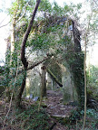
It was not long before we reached the end of Park Avenue and arrived at “Bushey Mill Lane”. As we looked around, we discovered the sign / entrance to the public footpath which was back to Fishers Field! The odd thing about the destination of this public footpath, was where was “The Otter” pub? Unfortunately the footpath signs have not been updated, as the pub is no longer there and some houses have since been built on the site 😦 So sadly there was no chance of a drink! So we decided to take the path back to the reserve.

As we started to walk along the path, I noticed that it ran alongside a stream. I wondered if this stream, had at one point a mill built alongside it? Particularly as we had just come from “Bushey Mill Lane”. It seems that this area was part of a large estate known as”Bushey Hall”. I cannot find out much about the mill, whether it was responsible for producing paper or flour, but from the size of the stream, I can’t imagine that it would have been on a grand scale? However, from the history of Bushey Hall, which at one time was an exclusive hotel during the 1880’s with many Hydrotherapy treatments, I am sure that the stream must have been adequate for for their needs too! Although I would need to read much more about it 🙂

From 2012 – 20.05.2012 – Fishers Nature Reserve – Bushey Mill Lane Walk

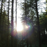
The footpath was narrow to follow, but it was still pleasant enough to walk along. On the other side of the stream was the Bushey Hall Golf Club, therefore it was not unexpected to find numerous lost golf balls in the stream! On one occasion the path seem to be walking through some woods rather than just past the golf course and stream. The trees were quite dense and it really did feel like a really lovely woodland walk.

It was almost a shame when the path suddenly seem to come to an end, when it reached a bridge to cross the little river. The bridge was to take us out into the Golf Course. Frustratingly for both of us, we spotted where we had been standing, at the beginning of our walk looking for this particular path to the Otter! As we crossed the course to the other path and looked across we were both confused why we did not see the bridge in the first place!

The little wooded copse, where the footpath goes through, in the course is actually “Scotts Wood”. Although I am unable to locate much information about the origins of Scotts Wood, I have learned that there is a theory that the name “Bushey” is derived from the Old English word “bysce” and Old French boisseie, meaning a “place covered with wood”. It certainly makes sense that Bushey earned it’s name that way! We followed the path back into Fishers Field, where we finished our short walk so we could adjourn for our Sunday Lunch… 🙂

For the morning’s photos, please feel free to scroll through them by clicking the photo below –

2012 – 20.05.2012 – Fishers Nature Reserve – Bushey Mill Lane Walk

<><

Trelawne Manor – Ten Acre Wood Walk – 02.05.2012

It was a pleasant evening, so we decided to take a stroll, no particular destination in mind, just enjoy the sun and warmth while we could. We started out from Trelawne Manor, home to the Trelawny family. I hasten to add the family has nothing to do by the famed Professor Trelawney from the Harry Potter (as far as I know ;-)) The beautiful manor has been around for over 400 years and despite being used by a holiday park, the original manor is still intact. The Trelawny name is in fact a Baronetage of England since 1628 when it was created for John Trelawany. The Trelawny family have been in the Clergy, in parliament, the Lord-Lieutenant of Cornwall and another the Governor of Jamaica. Such a mixed history!

From 2012 – 02.05.2012 – Ten Acre Wood

We found a nice little footpath to wander along, which took us past a lake. In fact this was known as a “The Pond” and had been created by Sir William Lewis Salusbury Trelawny (10th Baronet), out of a disused quarry in the grounds of the manor, in 1887. The pond was surrounded by some beautiful trees, in fact one of the them was a Chestnut Tree, which was planted in 1779 is still growing strong, despite being struck by lightning at one point! Evidence of this is an old photograph held by the family which shows the tree in 1889, it also portrays a beautiful pair of swans, which sadly did not stay, however the Lady Trelawny decided to breed ducks instead!

At this point the path passes a some sort of waterworks and then just seems to fizzle out! No public footpath signs or anything! We decided to return to the manor for help, where they dutifully gave us a map and told us to go back to the footpath we had just left! After a touch of deja vu… We eventually discovered that the path did not fizzle out but did in fact shrink substantially in size! We were entering “Ten Acre Wood”. I presume “Ten Acre Wood” refers to the wood size and nothing more. It certainly was not the 100 Acre Wood that would you would associate with Winnie the Pooh. I don’t think that Winnie the Pooh would have encountered the daunting and tumbled down building that found!

From 2012 – 02.05.2012 – Ten Acre Wood

This dilapidated building was in fact an old Lime Kiln. From the early 18th Century onwards, the Looe Valley had a thriving Limestone industry amongst other trades. Limestone was burnt in these type of kilns throughout Looe, to provide a lime fertilizer and later in the 19th Century to provide lime and stone for the building and engineering boom in Looe. To me, it was a sad reminder of how the industry had disappeared, and the building now just looked haunted, awaiting for someone to write some dark tale about it!

The trail took us deeper into the wood, and the afternoon stroll, turned more into a hike! I did feel like I was missing my rucksack and tent! The map that we were had was a little scant on directions, but I a know we did not quite stick to them! The path splits at one point and we took the high path instead of the lower path to follow the stream. The path took us out a muddy track, and we could vaguely see the West Looe River through the trees. We could also see the road below where would should have been according to the map!

Once we found a way down, we made our way over to the river. We had reached the edge of “Kilminorth Woods” These woods had a great walk, which we did not have time to do “The Giants Hedge” apparently is a nine mile ancient earth work bank, apparently 15 feet high and 24 feet wide in places. Historians so that it dates from the dark ages with theories saying it shows a boundary of a tribal chiefs kingdom in 10th Century, where as other say it could have been a “last-ditch” defence of the Cornish against the Saxon’s in the 9th and 10th centuries. Sounds like Offa’s Dyke! Out of all the theories I do like the legend the best –


Jack the Giant having nothing to do,
Built a great hedge from Lerryn to Looe.

We decided to turn around and take a different route back into Ten Acre Wood. The path took us along the stream, which we could only previously see from above. As we walked along we could see sun streaming through the trees, making the trees look tall and majestic. As we made our way along back up the trail, we passed by yet another abandoned Lime Kiln, which was not as clearly visible from the higher trail, and we eventually rejoined our original footpath.

We finished our short walk by returning to Trelawne manor and to eat some dinner, which needed after all that hiking!

To browse through all the photos of the late afternoon walk, please click on the photograph –

2012 – 02.05.2012 – Ten Acre Wood

<><

South West Coast Path – Talland Bay – Polperro Walk – 02.05.2012

“It’s a beautiful day
don’t let it’ get away…”

© U2 2000

It most certainly was! We were going to make the most of the most of this beautiful British Summer day :-). Starting out just above Talland Bay itself we were indulged with the amazing views across farmers fields and to the cliffs and sea. It was so wonderful to be able to see the Sun glittering on the sea! It looked almost magical! We passed by the car park before joining the South West Coast Path, which I have had the pleasure of walking many times before, please feel free to see my Cornwall blogs!

As we walked into the bay, we discovered that the bay did not most amazing sandy beach but it certainly enjoys a lovely feeling of being secluded. You could drinking tea at the little cafe there in peace! A little stream rushes through to the beach, definitely topped up by all the rain we have been having! However, Talland Bay itself seems to have suffered to the hands of Smugglers in 18th Century, it would not be hard to see why with the amount of coves, cliffs and rocks that we could see! I would have said it was not a place to miss if you came here, even Dame Judy Dench use to come here for childhood holidays :-).

We left the bay behind, to follow the path on a steep climb. The route joined the “Talland Cliffs”. At first it was lovely and cool under the trees, as they were over hanging the path, unfortunately they blocked the view over the bay :(. It was not long before the path reached a very small clearing, where a stone cross had been built. This is a war memorial cross had been placed purposely on this cliff, in dedication of the soldiers from Talland and Polperro. It looks out to sea where it dominates the skyline and has not been built where it can be hastily walked past like most crosses in a town centre. I will admit the view from the cross make view out the sea look quite infinite.

From 2012 – 02.05.2012 – South West Coast Path – Talland Bay – Polperro

As it was a very hot day, we came across a high number of walkers, and it was rather frustrating to pass in places particularly as it was a very narrow and rocky in place. However, I will admit not as difficult as the West Highland Way! The path took as high along the cliffs as we made our way towards the little village of Polperro. These cliffs are obviously dangerous to shipping as we could see a very small lighthouse in the distance. It was not very big as I could see people standing next to it and they were the same height as the lighthouse itself! Obviously it was seen as enough to warn boats away from these dreaded rocks…

Once the path had reached the top, it started to descend, as the saying goes “what goes up, must come down”. The path a steep descent, I was so glad that steps had been put into this section of that path to prevent any mudslides from happening! Eventually the muddy path gave way to tarmac. We could finally see the village of Polperro nestled into this natural harbour. As the path continued down the slope, we passed by some benches which had been strategically placed along the the path. It was extremely tempting to sit and soak up the sun and the view, but we felt that we were not going to do that today! We wanted to explore the sights and sounds of Polperro.

Polperro is small fishing village, which has been in existence since 13th Century. I will certainly say, when we arrived it has escaped so much development, it looks like a village that would fit in from 18th or 19th Century (maybe not 13th). We passed by the Polperro Musuem of Smuggling & Fishing, which we sadly did not have time to visit. Perhaps if we had, we could have read of the tales of smuggling took place and how the Polperro boats smuggled contraband goods across from the island of Guernsey on a large scale trying to evade capture of Revenue Vessels in the Channel, in the latter half of the 18th Century! I think these boats were in addition to ones I mentioned earlier to the smugglers on Talland Bay! This area was obviously notorious at that time… I think the occupation of fishing sounds much gentler, and this has been going on for generations in Polperro, it seems that Pilchards were the main catch at one time!

From 2012 – 02.05.2012 – South West Coast Path – Talland Bay – Polperro

As we started to explore the village, it was very noticeable how small the streets were. To be honest I think only bikes and pedestrians are able to get through them. Although we did discover later that runs a small tram service at the village centre! As we wandered on, we had a pleasant discovery that a small river runs straight through it. This is the “River Pol”, where Polperro derives it’s name from. Polperro is from the Cornish “Pol” which is pronounced as “Pole” which can mean either of the following – “Pool”,”Pit” and “Cove”, in Cornish Polperro means “Pera’s Cove”. All the houses over hang the river, looking very precarious, but beautiful at the same time :).

We continued around the harbour to walk a little way up the other side of the South West Coast Path, it was far steeper and rockier than the Talland Cliffs. Probably more dangerous for shipping. There was an abandoned building on the edge of the cliff, surprisingly still intact and it not given into the ravages of the sea. I am still unsure what it was? However, from reading more about Polperro, I am sure this was to do with the fishing industry perhaps where fish was taken to be packed and prepared once it was caught? If anyone is prepared to let me know I would really appreciate it!

We decided not to continue along the coast path, and keep that walk for another day. We turned back to Polperro to enjoy the sights and sounds of the village once again. To really finish the walk I treated myself to a Wright’s Ice Cream only made in Polperro scrummy – well worth a walk for 🙂

Please feel free to enjoy the walk photos!

2012 – 02.05.2012 – South West Coast Path – Talland Bay – Polperro

<><

Trelawne – Looe Walk – 01.05.2012

This walk was not to lead us down footpaths, but to take us down narrow lanes.   Mostly used by farmers I would have imagined since a normal car would struggle to get through most of them!    As the lane took us uphill it blessed us with a view over the fields and despite the threatening rain clouds it was still rather pleasant.   It was not long before we were no longer in the open and it became dark and foreboding as the overhanging trees made the route seem rather uninviting.

From 2012 – 01.05.2012 – Trelawne – Looe Walk

We were passing by Vensloe and Kiln woods. The Kiln Woods contain a quite a number of deserted Lime Kilns which once dominated the industry in the area. We came across a number of these in a walk later on during our stay in Cornwall, so I will blog some more on this later! These woods provided inspiration of what is known as the Carrion Woods in the PC Game called “The Lost Crown”

We left these rather daunting woods behind, as the lane started to climb once again. It took us past some more the beautiful countryside surroundings. The fields are definitively well cultivated and were a lush shade of green. It showed how the rain that we had been suffering of late has been benefiting our landscape. The immense amount of rain had also topped up the “West Looe River”, which as we passed by, as it was flowing at a tremendous rate.

Wandering on, the Lane continue to rise giving us an even better view across the fields and back across to the “West Looe River”. We had a big bonus when the sun began to appear along with some lovely blue skies, something which had been missing from us for quite a number of weeks. The lane twisted and turned taking us downhill and past Trewith Wood. It was here that we were to cross “East Looe River” Over the bridge we had to cross the Looe Valley Train Line. I have to say, that this was not the safest level crossing I have ever seen, particularly as there were no barriers and no warning signals to say a train was coming! It seems that your eyes were the best warning!

From 2012 – 01.05.2012 – Trelawne – Looe Walk

We were no longer walking any of the country lanes, but walking along a busy roadside. Finally, the “Welcome to Looe” sign homed into view through the trees. This was actually quite nice to see, as this route was a slightly longer than planned when we first decided to walk to Looe! The road passed by a beautiful lake and what is known as St Martin’s Copse. St Martin’s is part of a Parish and although we did not get to see it St Martin’s Parish Church, a local Thomas Bond, the topographer is buried in the churchyard. He was responsible for the publication “Topographical and Historical Sketches of the Boroughs of East and West Looe…”

As their are no pavements on this section of the road, it felt quite hazardous at this point as it was a reasonably busy section. Quite a few cars and delivery vans whizzed by making me feel very nervous. But it was not long before pavement honed into view and we were able to cross over to admire the amazing view over the river to West Looe village. The houses were placed hiccidly piccidly over the hillside which just added to its charm 🙂

Although we know it as Looe, it seems that actually they should be two separate villages. It seems that one of the things that joins the two entities is the bridge over the River Looe. The first recorded bridge that was a wooden bridge built in 1411, which was destroyed by fire. Replaced by a larger stone bridge with a chapel dedicated to St Anne built in the middle which was built in 1436, this fell into disrepair and eventually replace in 1853 by the bridge that stands today. I have to admit to see a Chapel standing in the middle of a bridge must have been pretty stunning, reminds me of the what how they tried to build London Bridge when they had all those shops and houses on it!. We passed by the station and bridge, and into the streets of East Looe. We then headed towards the Quay and seafront.

We spotted a seal across the water – how lovely! but it did not move a statue? Maybe we could investigate later? We passed by the Banjo Pier, designed and built by the Civil Engineer Joseph Thomas. The pier is an odd shape as it as has round circle at the end of the pier, to end the silting in the harbour. The town did not believe in idea so he financed for the “Round” out of his own pocket! I was struck by stone needle, which is a little smaller than Cleopatra’s needle which is situated in London, but still as striking! . We headed back to the town centre only to spot a tiny museum which was built in the 15th century. In fact this was the Old Guildhall & Gaol (Jail) Although I am not sure if you were very tall if u could get up the stairs LOL. (but please try and visit!!)

From 2012 – 01.05.2012 – Trelawne – Looe Walk

We felt that it was time to go to West Looe to investigate. We crossed over the bridge, to the other side of the Quay. It was here I found a stone which had been “Laid HRH Prince George, 24th June 1931”. Although I am unsure if I can find out any further information about this, can anyone let enlighten me? West Looe, is very much smaller than East Looe, and the roads are much steeper and narrower! I was not surprised to see that the route to many of the houses were hundreds of steps uphill!

West Looe had a tiny church, it was very peaceful to enter and I could have spent hours in there! I noted that Joseph Thomas name was on the front of the Church, obviously had been responsible for quite a bit of the structural building in Looe. He had built the road out of West Looe, a part which we did not walk, which was supported by some amazing arches. You will be able to see them in my photo here. The road was opened in 1895, there are 4 arches in total and they carry the road along the steep cliff to Hannafore. As he used ornamental buttresses I mistakenly thought it was an old castle!

We finished our walk by the seal which we spotted earlier, in fact this was statue dedicated to the One Eyed Bull Seal “Nelson” who used to swim these waters regularly for 25 years. He was fed by visitors, fishermen and residents alike. This beautiful bronze statue was created in his memory How lovely!

For all of the walk please feel free to browse my photos –

2012 – 01.05.2012 – Trelawne – Looe Walk

My Walking route is as follows

<><