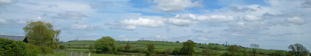
It was a stunning afternoon, and I had another chance to explore yet another part of the South West Coast Path. The sun was shimmering over the horizon, making a wonderful haze, I could have just looked over the cliff edge at the ever changing sea for the rest of the afternoon if I am entirely honest. But it did not take long for the walker in me to take over and start wandering along the track.
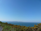
The path was to take us along to the “Berry Head”. It seemed like an easy enough route to me, straight ahead and uphill? Yet the “South West Coast Path” does not follow the Coastal route! The path actually took us around and into the Berry Head Visitors Car Park. It was not long, however, before the path rejoined the other “coast path” as I nicked-named it! The path then took us up to the Berry Head, where it stops short of the Cliff. I was brave enough to look across the cliff edge where I was rewarded with views across “Torbay”.
 |
| From 2012 – 25.05.2012 – South West Coast Path – Berryhead Walk |
We left the path at this point, as the path continues to Brixham. We decided to follow that route the next day. Instead we headed towards the Napoleonic Fort, that is sighted on the Berry Head. This impressive Fort which was built on a limestone peninsula which is at least 65m (200ft high) . The fort was built during the Napoleonic Wars, 1794 – 1804, it’s main objective was to protect Brixham and Tor Bay from French attack.
As we passed through the very high and impressive gateway into the fort, there are sudden lack of buildings just a large expanse of grass. The outlying walls of the fort are still intact, giving us a good idea of exactly how large the Fort would have originally been. In fact it showed that the Fort would have been a similar size to the peninsula, as the walls seem to hug the Coastline. I would imagine that the fort could have been very daunting to any approaching ships in it’s hey day
 |
| From 2012 – 25.05.2012 – South West Coast Path – Berryhead Walk |
As we started to explore the fort, I was nicely surprised to find a Beacon! This will have been the 8th Beacon I have located on my travels around the UK. If you like to read some of my other walks, Berwick Upon Tweed Walk, Purfleet, Wemyss Bay, Hainualt Country Park, Doniford Bay ,Canvey Island and Hastings all of these have had a beacon find! I am no longer going to name them “Millennium Beacons”, as they have since been lit for the Queen’s Diamond Jubilee. However, I have found out that approximately 4,500 beacons were lit on 4th June 2012 and if so I have only 3,492 to locate:-/
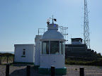
As we walked further out onto the Peninsula, it was became much easier to see how the Fort really dominated the bay. We began to really see how far out into the sea you are really able to see on a good day. In fact on a from one point, over 800 sq miles of Sea are visible! I doubt any approaching ships would have been able to hide from this Fort! We were not surprised, then, to find a Lighthouse built on the remains of this Fort, surely it can be seen for miles around. It was constructed in 1906 and the Lighthouse is the “smallest, highest and deepest” Lighthouse in the UK. As the Light was originally required to be turned by a weight in the 45m (~147.6ft) shaft below it, which has now been replaced by a small motor.
 |
| From 2012 – 25.05.2012 – South West Coast Path – Berryhead Walk |
As we continued our walk around the Fort we discovered a well preserved Artillery Store for the Royal Regiment, which would have been used in approximately 1802. It seemed the Fort was not only used during the Napoleonic wars but during World War II as well. An Observation Post had been built here, which had been used by Royal Observer Volunteers to spot Enemy Aircraft. As we wandered our way out of the Fort, we walked past the Visitor Centre, which was surrounded by Canons, presumably these were originals from the site? I am not sure? Having seen them up close, and knowing that there would have have been a whole host of these guns pointing out to sea at one time in history, that would have been a very frightening sight
As we left the Northern Fort behind, it was time to walk to the “Southern Fort”. This time, we choose not to walk along the South West Coast Path. We walked along a path which was of the “Torbay Circular Walks”. The Path was a lot nicer to walk along, particularly as the route followed the Coastline. It was not long before we reached the Southern Fort, which unlike the Northern Fort, did not have a large Stone entrance. Perhaps that was long gone, the drawbridge had been reconstructed over the Moat which was still clearly visible (It was more like a ditch, as there was clearly no water in it!)
The Fort was built at the same time as the “Northern Fort” during the Napoleonic Wars, it seems that this Fort was a lot smaller that it’s counterpart, particularly as it contained only a single Barrack. The Fort is located on a a higher ridge and facing out in a slightly different part of the bay. The high walls and moat gave the Fort a great position the defend inland attacks as well as attacks from the sea.
As we explored inside the Fort, it was noticeable that this Fort had been adapted for use during the Second World War. An observation post had been put up so that someone to climb it and look out to sea to watch for those enemy ships. Lovely on days like we were visiting, but not on those cruel windy nights when the sea could be lashing against the cliffs!
 |
| From 2012 – 25.05.2012 – South West Coast Path – Berryhead Walk |
We left the fort behind to continue along our chosen path, which eventually joined up with the South Coast Path once more. We finally reached a stop point when a cup of tea was in order before starting out on the path once more.
This part of the path was certainly less glamorous. It was narrower and took at one point I got confused when I saw the sign “Private Property”. Please keep to the path at the bottom of the field! I wasn’t sure I was at the bottom of any field? ! All very confusing, luckily I had just passed two walkers coming the other way so I knew I was ok! After walking through the field the path became very steep, I am glad that their had been no rain that day, because I had not been wearing walking boots and I would have definitely slipped on the mud if that was the case!
This stretch of the path was lined with trees, which hindered a lot of the lovely coastal views. Luckily at one point there was a small gap, where I could see the little Bay. This was St Mary’s Bay, which really beautiful to walk along. Unfortunately, I did not have any more time to continue my walk that evening to venture any further on along this route 😦 If I had more time to walk I would have been able to reach Sharkham Point. Despite me ending my walk here, I was not too sad I was going to do more walking the next day!
For all the afternoon/evening walk photos, please feel free to browse them, by clicking on the photo here –
 |
| 2012 – 25.05.2012 – South West Coast Path – Berryhead Walk |
<><

Pingback: South West Coast Path – Berry Head – Churston Cove – 26.05.2012 « Karen's Sponsored Walks
Pingback: Borehamwood – Edgwarebury Walk – 08.07.2012 « Karen's Sponsored Walks
Pingback: Weymouth Walk – 13.10.2012 « Karen's Sponsored Walks